- Mobility & Infrastructures
Categories:
On August 26, 1983, the Basque Country suffered the worst flooding in its history: 1,500 million cubic meters of water that ended the lives of 43 people. It was, without a doubt, the region’s worst natural disaster of recent decades. On the 25th, 26th and 27th of that month, the Atlantic coast of Cantabria recorded exceptional rainfall, as described in this video.
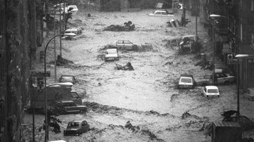
On this occasion, the heavy rains were due to high instability caused by an exceptional cold drop; the surface maps for those days showed a stable high-pressure area, with high temperatures in Bilbao of 25 °C and a low of 18 °C. By contrast, there was a cool air mass aloft at a temperature of -12 ° at an elevation of around 5,700 meters. It was this cold air mass, located over a layer of moist, hot air that rose after running into the mountain ridges of Cantabria, that triggered a condensation process, forming clouds with high vertical development and strong precipitation in a very short period.
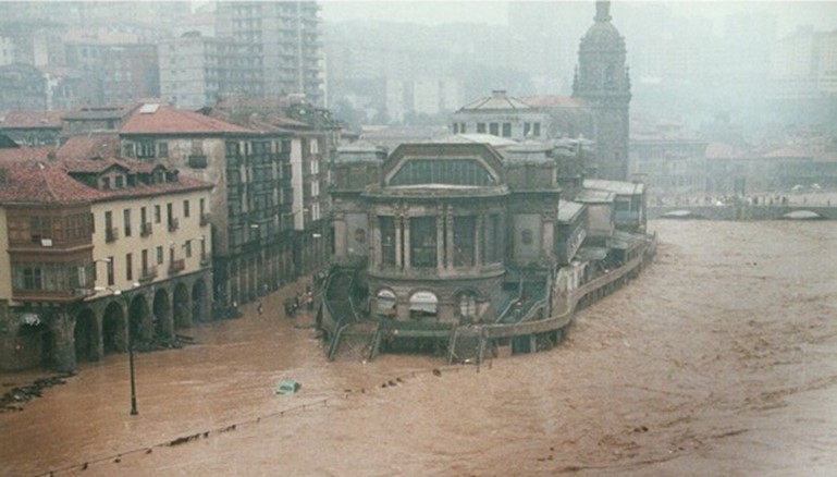
Following this event, the Basque Government commissioned Sener to draw up the Comprehensive Flood Prevention Plan for the Autonomous Community, which was completed in 1991. It included the rain, hydrological and hydraulic studies needed to evaluate the protection alternatives, and analyzed the water safety of reservoirs, several of which had overflowed in 1983. It also made regional planning recommendations involving the monitoring network and the communication and alert plan.
Ever since, similar projects have been conducted by Sener where the previous methodology was applied, updated with the latest technology, for different water authorities. Examples include Planning of the Tordera and Francolí River Areas drafted for the Catalan Water Agency; studies on the boundaries of the flood zones of the Aragon and Irati river basins, as well as of the Cantabrian basins for the Government of Navarre; and hydraulic studies to prevent flooding in the Guadalhorce and Poniente Almería basins for the Andalusian Water Agency.

Between 1998 and 2004, Europe experienced more than a hundred serious floods. These events displaced approximately half a million people and caused at least 25 billion euros in insurance claims. As a result, in October 2007 the European Commission adopted a directive to assess and manage floods that introduced a new approach and instruments to manage this type of risk, and which was transposed into Spanish law through Royal Decree 903/2010 of July 9, to assess and manage flood risks, which anticipated three successive phases and is reviewed every six years: the preparation of a preliminary flood risk assessment that defined areas at risk of flooding, the preparation of the hazard and risk maps for each of these areas, and the drafting of the flood risk management plans (FRMP).
In short, the FRMP aim to achieve a coordinated response from all government agencies and society to reduce the negative consequences of flooding, based on the sets of measures that each agency has to implement as part of its responsibilities in order to achieve the goal of reducing the negative consequences to human health, the environment, cultural heritage and economic activity, associated with flooding.
The status of the FRMP in Spain
Currently, there are 12 approved second cycle FRMP in Spain, while the rest are being processed in accordance with the provisions of the Royal Decree. The planned investment in inter-community boundaries for this second cycle, corresponding to the next six years, is 2 billion euros, which is more than a two-fold increase in the budget with respect to the first-cycle plans approved in 2016. Specifically, €678 million will be allocated to regular annual measures, and €1.322 billion to ad hoc actions.
The measures proposed in the FRMP are binding, with the European Community being responsible for enforcing the goals established in each case. Moreover, the plans are updated every six years and are integrated and coordinated with the River Basin Hydrological Plans. As a European regulation, the international basins are equally coordinated.
The fruits of this continuous planning, monitoring, and updating can be quantified; the following graphs, taken from the FRMP of the Basque Country drawn up by Sener, show a comparison between 2015 (red) and 2021 (in blue completed, and in green completed and in progress) of the exposed population (left) and of the economic damage (right) caused by flooding, as an annual average. Both cases show a significant improvement of the indicators mentioned.
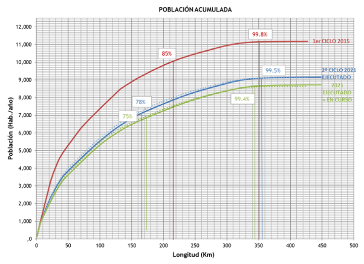
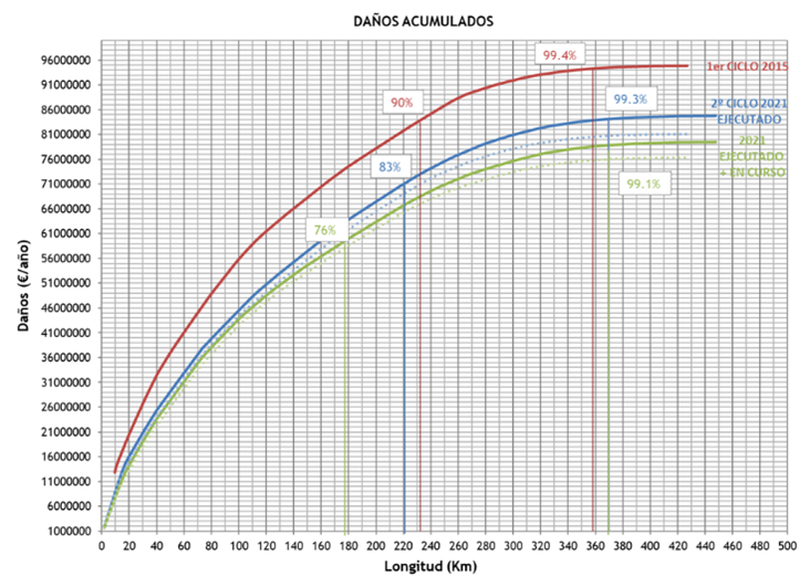
We can thus conclude that the approach being taken to deal with the flooding problem seems appropriate, especially if the new challenges posed by climate change are considered.
Óscar de Cos
Senior Consultant in Water and Environment
Civil Engineering degree from the University of Cantabria, programs in Disaster Risk Management (WB and Delft), Natural Disaster (McGill University) and Global Warming Science (MIT). He has 33 years of experience as a designer, project manager, business promoter and consultant, primarily in the fields of hydraulics, hydrology, flood prevention, real-time decision-making support systems, water planning of basins, water supply and sanitation works, flood protection and dam safety.

 About us

