


- Mobility & Infrastructures
Categories:
In a global context marked by the climate emergency, flood risk management has become a strategic priority for the safety of people and the resilience of infrastructure. It is estimated that approximately 10% of the world’s population lives in low‑lying areas at risk of flooding, representing hundreds of millions of people exposed to increasingly frequent and extreme weather events.
Within Spain, particularly in regions with complex orography such as the Basque Country or the Canary Islands, vulnerability to sudden flash floods demands a shift from passive protection models to proactive, anticipation‑based management.
The risk context: a global and local challenge
Fluvial and coastal floods not only cause millions in material damage but also put human lives and the socio‑economic stability of entire regions at risk. Even with physical protection measures such as embankments or channel alterations, the possibility of events exceeding design thresholds remains a persistent reality.
A recent example was the extreme rainfall in the summer of 2021 in Central Europe, which caused devastating floods in Germany and Belgium and significantly affected river basins in the Netherlands.
As climate change alters precipitation patterns—intensifying DANA events and episodes of torrential rain over short periods—response capacity becomes critical.
In regions with fast‑responding catchments, the time between rainfall and peak flow is minimal, making high‑resolution predictive tools essential.
The role of Early Warning Systems (EWS): Deltares’ leadership
Early Warning Systems (EWS) play a fundamental role in transforming meteorological and hydrological data into actionable information. An EWS is not only a mathematical model: it is an integrated chain that enables authorities and the public to prepare and respond adequately before, during and after a disaster.
Their main function is to provide vital lead time for:
- Preparation: activating evacuation protocols and protecting critical assets.
- Response: informing emergency services of the most affected areas in real time.
- Recovery: assisting in crisis management following the event.
The effectiveness of these systems lies in their capacity to integrate local observations with global prediction models, ensuring that alerts reach those who need them with enough notice to save lives.
To bring all these requirements together in a single platform, Deltares, an independent research institute based in the Netherlands, has led the development of flood forecasting systems worldwide. In its home country, Deltares develops and maintains the official system for the Ministry of Infrastructure and Water Management.
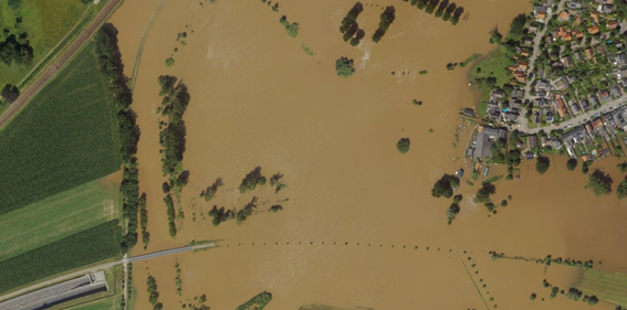
During the 2021 event, although the Meuse River reached exceptionally high levels in Limburg, forecasts allowed authorities to prepare in advance. Despite flooding in areas outside the dykes, the main embankments held thanks to management informed by the models. Following this event, Deltares launched research missions to assess how other parts of the country would respond to similar rainfall, strengthening preparedness across regional water boards and national authorities.
Figure 1. Flooding in Limburg, the Netherlands. July 2021. Source: https://specials.deltares.nl
Delft‑FEWS: The platform behind Tenerife’s EWS
The cornerstone of these advances is Delft‑FEWS (Flood Early Warning System), an open‑source software developed by Deltares that has become the international standard, deployed in more than 50 countries. In Spain, this platform has been successfully adopted by various river basin authorities, including the Basque Water Agency (URA), as well as the Júcar, Segura and Tagus catchments.
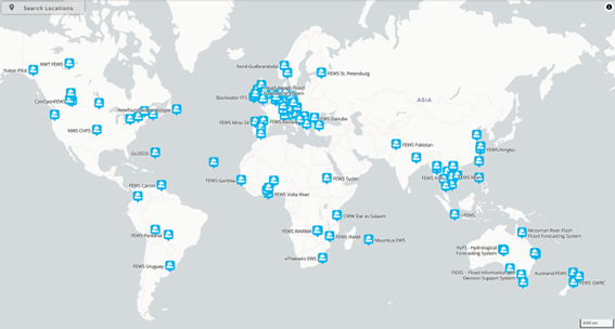
Figure 2. Locations that have implemented a “Flood Forecasting” system. Source: https://fewsmap.deltares.nl/topology/node/floods/map
Delft‑FEWS is not a model, but a modular and flexible environment that enables:
- Integration of multiple data sources, from weather radars and satellites to real‑time gauging stations.
- Execution of different hydrological models through its open architecture, allowing basin‑specific models to be coupled without licence costs.
- Scalability, as it can run from a single computer to complex national‑level server‑client systems.
Promoting the development of cutting‑edge technologies, Sener has developed and implemented for the Island Water Council of Tenerife (CIATF) a pioneering EWS adapted to the unique orography of the Canary Islands.
System architecture
The system implemented by Sener uses the Delft‑FEWS platform under a robust architecture:
- Front‑end: FEWS user interface for visualisation and manual management.
- Middleware: FEWS application server managing logic and workflows.
- Back‑end: MySQL database and file servers for historical and operational storage.
Operation and modelling
The system captures meteorological data from various sources, including automatic stations (EMAs) of Agrocabildo and Grafcan, as well as forecasts from AEMET (HARMONIE and Radar models) and the global GFS model.
Its functioning is designed for two operational scenarios: “cold start” for initial runs, and “hot start” for continuous operation, in which models run every 10 minutes to reflect antecedent basin conditions and predict its response to new rainfall.
The system’s intelligence relies on the combined use of two hydrological model types:
- TETIS: A distributed conceptual model reproducing the hydrological cycle through a water balance in each terrain cell.
- TOPKAPI‑X: A physically‑based distributed model dividing each cell into four elements (surface soil, deep soil, surface flow and channel), enabling precise simulation of runoff and subsurface flow.
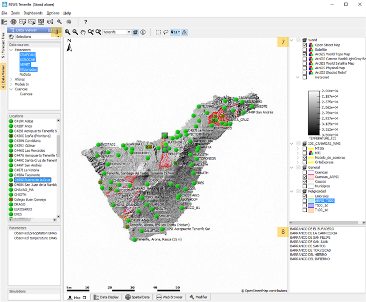
Figure 3. Interface of Tenerife’s Early Warning System. Source: Own elaboration.
Results and operational capabilities
With the goal of providing CIATF with superior response capacity, Tenerife’s EWS has become a comprehensive control platform. The system transforms complex data into visual and actionable information, enabling efficient crisis management through:
- Dynamic risk mapping, with interactive maps zoning vulnerability in real time according to hydrological variables and alert levels.
- Advanced dashboards, enabling intuitive visualisation of time series for rainfall, flows and reservoir status, ensuring precise catchment monitoring.
- Automated alert protocols, whose activation generates warnings based on critical thresholds of rainfall and runoff, essential for anticipating impacts at the most sensitive ravine points and gaining vital time for civil protection.
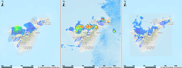
Figure 4. Interactive map of rainfall evolution over different time periods. Source: Own elaboration.
- flooding
- flood management
Tags:

Diego Andrés García Mendivelso
Diego Andrés García Mendivelso is a civil engineer with over twelve years of professional experience, including a master’s degree in civil engineering with a specialization in Water Resources and an international master’s degree in BIM Management for Civil Engineering. He is currently a project engineer specializing in hydrology, hydraulics, and flood risk, where he leads the development of flood mapping in the Basque Country and Catalonia by creating 1D and 2D hydraulic models to delineate risk zones. His professional approach integrates programming and efficient data management to develop resilient solutions to climate change, aimed at strengthening water security in highly complex technical projects.

