


- Mobility & Infrastructures
Categories:
In the management of the integrated water cycle, the statement “what cannot be measured cannot be managed” remains as true today as ever; however, measurement methodologies have undergone a radical transformation. Over the past century, we have moved from heroic expeditions to read a staff gauge in a remote river to receiving terabytes of real-time information from space. It is fascinating to analyse this transition, exploring the technical evolution until we understand the disruptive impact of remote sensing and how SCADA architecture has redefined the accuracy of our current models.
At the beginning of the last century, hydrology was a science that demanded extreme patience and physical presence. Engineers and observers relied almost exclusively on manual gauging stations, where data collection was limited to visual readings from scales (staff gauges) and mechanical current meters to measure flow velocity. This work required whole days in the field, often under severe weather conditions and facing significant personal risks just to obtain a single data point.
For decades, information was collected following the same pattern, imposing a critical limitation: data were discrete. We only knew the state of the river at the precise moment of measurement, leaving a gap in temporal resolution. If a flood wave occurred at night or between technical visits, the peak was often missed, forcing hydrologists to estimate levels using water marks on vegetation or bridges, or even relying on local testimonies to reconstruct the magnitude of the event.
In the mid-20th century, the introduction of float-operated chart recorders represented an undeniable qualitative advance. However, despite providing continuous records, the data were still analogue and remained trapped on paper until a technician digitised them manually. This historical constraint meant that both hydrology and hydraulics were, for a long time, sciences of retrospective statistical analysis rather than tools for proactive, real-time management.
The paradigm changed definitively with the arrival of solid-state electronics and radio communications in the 1970s and 1980s. In Europe, Spain was a pioneer in this leap with the implementation of the SAIH (Automatic Hydrological Information System) of the Júcar basin, operational since 1989. After the devastating floods of the 1980s, it became clear that the basin needed to be treated as a living organism, constantly monitored. For the first time, this system enabled real-time tracking of meteorological and hydrological variables, facilitating resource management and the response to extreme floods and droughts.
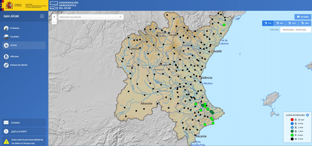
WebSAIH Dashboard – Confederación Hidrográfica del Júcar.
This automation allowed pressure and ultrasonic sensors to replace the old float systems, but the true benefit came with telemetry: the ability to transmit data via satellite or radio to a control centre. In Australia, a continent marked by climatic extremes, the Bureau of Meteorology (BoM) refined these networks to manage severe water scarcity, demonstrating that automatic data is above all a tool for social and economic survival.
However, despite the efficiency of automatic networks, data remained point-based; we knew what was happening at the sensor, but not across the thousands of square kilometres between stations. This is where remote sensing has triggered an unprecedented disruption. Satellite missions such as the ESA’s Copernicus (Sentinel) or NASA’s Landsat programmes now allow us to observe previously inaccessible variables: from actual evapotranspiration to optimise irrigation, to soil moisture and centimetre-precision Digital Terrain Models (DTMs) captured through LiDAR technology.
This benefit is evident in developed regions such as the Mississippi River basin or the plains of Central Europe, where floods can be mapped in real time. But its value is even greater in regions with little in situ measurement. A notable example is a study conducted in Pakistan (2010–2020), where the MODIS sensor and Google Earth Engine were used to map floods. Thanks to its high temporal resolution and spectral capacity, MODIS helped overcome the limitations posed by monsoon cloud cover, generating critical risk maps for emergency response in vulnerable communities.
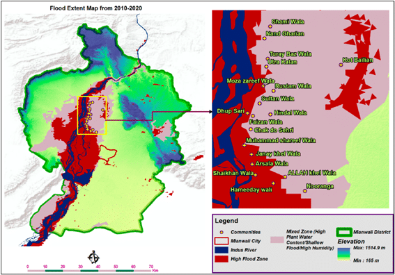
Map of the cumulative extent of flooding in the study area for the period 2010-2020.
The SCADA Synergy and the Calibration of Models
The most advanced stage of this technological chain is the integration of these data streams into SCADA (Supervisory Control and Data Acquisition) systems. Historically, calibrating a model—whether hydrological or hydraulic—was a trial-and-error process based on static events. Today, SCADA architectures enable data to flow directly from the sensor to the model in a constant loop, removing outliers through automated cleaning algorithms and allowing real-time data assimilation.
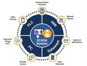
Information sources for SCADA systems.
The evolution of data capture over the past century has given engineers an “X-ray vision” of the hydrological cycle. Thanks to SCADA infrastructure and Big Data, our models are no longer mere theories but dynamic replicas of reality. In the context of climate change, this ability to refine calibration and predict events accurately is the frontier between disaster and resilience.
As water professionals at Sener, an organisation at the forefront of innovative solutions, our mission is to expertly connect this data ecosystem to each of our analyses. The challenge today is no longer the mere acquisition of information, but its integrated and strategic management. At Sener, we work to ensure that this technical precision translates into greater resilience for our communities, guaranteeing intelligent, sustainable stewardship of our most precious resource: water.
- water management
Tags:

Diego Andrés García Mendivelso
Diego Andrés García Mendivelso is a civil engineer with over twelve years of professional experience, including a master’s degree in civil engineering with a specialization in Water Resources and an international master’s degree in BIM Management for Civil Engineering. He is currently a project engineer specializing in hydrology, hydraulics, and flood risk, where he leads the development of flood mapping in the Basque Country and Catalonia by creating 1D and 2D hydraulic models to delineate risk zones. His professional approach integrates programming and efficient data management to develop resilient solutions to climate change, aimed at strengthening water security in highly complex technical projects.

