


- Mobility & Infrastructures
Categories:
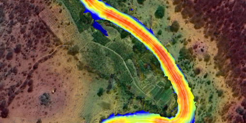
The increasing frequency and intensity of extreme rainfall events make the development of two-dimensional hydraulic models essential for the analysis of water bodies and flows. These models enable the determination of flood levels and overflows associated with extraordinary flood events and are fundamental tools in hydrological studies and the planning of drainage infrastructure.
In the face of the growing challenges associated with extreme flood events witnessed worldwide, at Sener we are committed to continuous improvement and the optimisation of processes in the development of hydraulic models. Our aim is to enhance their applicability and achieve the most accurate representation of such events possible, to support better decision-making.
To achieve reliable results that accurately represent real (current and future) hydraulic behaviour, it is crucial not only to have validated, specialised software but also to use high-quality inputs, verified by the design engineer. In this context, the following key aspects are particularly relevant:
Terrain characterisation
It is essential to have up-to-date and accurate Digital Terrain Models (DTMs) or topobathymetric models, with resolutions tailored to the type of terrain. In flat areas, where slopes are minimal, a higher point density is required for correct representation of surface flow. In contrast, mountainous regions usually have more clearly defined channels, allowing for a lower data density.
In software such as HEC-RAS 2D or Iber, the accuracy of the digital terrain model directly affects the quality of the computational mesh and the definition of the calculation domain. These models should be supplemented with field inspections, satellite or aerial imagery to identify inconsistencies, incorrectly represented drainage directions, or physical obstructions that could significantly alter model outcomes.
Soil characterisation
A proper characterisation of soils, vegetation cover, land use, and antecedent moisture conditions is essential—ideally based on up-to-date observations from basin management authorities familiar with the current state of channels, banks, and flood-prone areas. This should be complemented by a basic geomorphological analysis of the study area for a comprehensive understanding of local conditions. This information helps define parameters such as Manning’s coefficients or Curve Numbers (CN), which directly affect surface flow modelling and influence results such as flow velocities or effective discharges.
Hydrological processes and flow generation
Though it may seem obvious, proper hydrological modelling is critical for the estimation of design flows. A rigorous comparison of methodologies (empirical, statistical, and physical) should be carried out, calibrating results against historical records and considering factors such as climate change and specific catchment yields.
With the integration of software such as HEC-HMS, a direct link can be established between hydrograph generation and its subsequent use in hydraulic modelling. In more focused studies or smaller areas, effective rainfall data incorporated as input files allows for combined rainfall-runoff analysis. This makes it possible to simulate rainfall-runoff events with a high level of precision—especially useful in urban areas or small catchments.
Boundary conditions and model configuration
The accurate definition of boundary conditions—both inflow and outflow—is crucial. For instance, the location and extent of incoming flow can significantly alter the distribution of water and the simulated flood levels.
In HEC-RAS 2D, inflow and outflow boundary conditions can be defined using normal or critical depths or time series. IBER allows the definition of steady or unsteady flows, specific discharges, fixed levels, and other dynamic conditions. Choosing the correct boundary conditions has a major impact on model stability and interpretation.
Numerical configuration and model parameterisation
Meshing the analysis area, defining break lines, setting flow directions, and accurately representing hydraulic structures (bridges, weirs, culverts, etc.) and potential terrain modifications (dykes, dams, channels, etc.) must be undertaken with care. Numerical parameters such as cell size, geometry and orientation, time steps (often calculated based on the Courant number), and the choice of solution type (diffusive wave or full momentum) directly influence model stability and accuracy. Both software tools offer explicit and implicit solution schemes, which should be selected based on study objectives and terrain complexity.
Calibration
Lastly—and by no means of lesser importance—model calibration, which is rarely conducted in early-stage studies but is highly important in complex and high-risk studies where critical infrastructure or populations may be affected. Verifying key channel sections, comparing field-detected flood marks with historical water level records, and conducting interviews with local residents are just some of the approaches that can help validate that flood extent and depth outputs match real flood event behaviour in the area under study.
Conclusion
Developing a two-dimensional hydraulic model should not be viewed simply as a water level simulation exercise. It is a complex, detailed, and multidisciplinary process aimed at understanding the hydrodynamic behaviour of fluvial or pluvial systems—particularly important in a context of increasing climate variability.
Both HEC-RAS 2D, developed by the US Army Corps of Engineers, and Iber, a joint initiative between the International Centre for Numerical Methods in Engineering (CIMNE) and the University of A Coruña, are robust, widely validated, open-access tools offering advanced capabilities for such purposes.
However, more important than the modelling tool itself is that the responsible engineer possesses a solid hydrological-hydraulic knowledge base. Qualified personnel are needed—those who understand the governing equations of the model, can validate results and interpret them correctly, and can make the right decisions at each stage. Only in this way can a model be as effective as possible and meet the specific needs of a project depending on the design phase.
Proper implementation of these models is key to informed decision-making in infrastructure projects, risk management, and spatial planning. For this reason, it is essential to have a team of water engineers with extensive knowledge and experience in rainfall analysis, hydrological and hydraulic studies, and river and stormwater engineering projects. At Sener’s Water Technologies team, we have been conducting this type of study for decades, using both 1D and 2D hydraulic models across our Water and Environmental projects, supported by all types of specialised software.
Author

Freddy Leveri
A civil engineer specializing in environmental sanitation and with a master's degree in hydrology and water resources management, he has 20 years of experience in the fields of hydrology and hydraulics, with extensive experience in linear infrastructure projects, design and coordination of urban and rural drainage system studies, hydrological studies, and channel flooding studies.

